![](/images/other/stat-length.png)
![Randonnée A pied Wohlen bei Bern - Illiswil - Weiermatt - Photo](https://media.geolcdn.com/t/1900/400/17e0f03d-022a-4564-a90c-72ed4fe0e52d.jpeg&format=pjpeg&maxdim=2)
Illiswil - Weiermatt
SityTrail - itinéraires balisés pédestres
Tous les sentiers balisés d’Europe GUIDE+
![Longueur](/images/other/stat-length.png)
Longueur
3,2 km
![Altitude max](https://static1.geolcdn.com/siteimages/upload/files/1508320355ic_sort_altitude_max_24dp.png)
Altitude max
657 m
![Dénivelé positif](https://static1.geolcdn.com/siteimages/upload/files/1508320355ic_sort_den_pos_24dp.png)
Dénivelé positif
110 m
![Km-Effort](/images/other/stat-length.png)
Km-Effort
4,4 km
![Altitude min](https://static1.geolcdn.com/siteimages/upload/files/1508320355ic_sort_altitude_min_24dp.png)
Altitude min
572 m
![Dénivelé négatif](https://static1.geolcdn.com/siteimages/upload/files/1508320355ic_sort_den_neg_24dp.png)
Dénivelé négatif
30 m
![Boucle](https://static1.geolcdn.com/siteimages/upload/files/16400158638029165_repeat_loop_refresh_sync_direction_icon.png)
Boucle
Non
Balise
Date de création :
2022-02-14 08:50:58.675
Dernière modification :
2022-02-14 08:50:58.675
![A pied](https://static1.geolcdn.com/sitytour/trail-icons/100.png)
59m
Difficulté : Facile
![Scannez ce code QR pour ouvrir la randonnée dans l'application SityTrail](https://capi.geolives.com/qq0zvz2zws4bq2lad0pu/sitytour/trails/3106396/qr.png?size=200)
Application GPS de randonnée GRATUITE
À propos
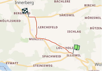
Randonnée A pied de 3,2 km à découvrir à Berne, Arrondissement administratif de Berne-Mittelland, Wohlen bei Bern. Cette randonnée est proposée par SityTrail - itinéraires balisés pédestres.
Description
Randonnée créée par Berner Wanderwege.
Symbole: gelber Diamant
Localisation
Pays :
Suisse
Région :
Berne
Département/Province :
Arrondissement administratif de Berne-Mittelland
Commune :
Wohlen bei Bern
Localité :
Unknown
Départ:(Dec)
Départ:(UTM)
373613 ; 5203741 (32T) N.
Commentaires
Randonnées à proximité
![Randonnée A pied Wohlen bei Bern - Illiswil - Wickacher - Photo](https://media.geolcdn.com/t/375/260/60a1bd14-b657-48fb-bd1f-2ef6d179fb2f.jpeg&format=jpg&maxdim=2)
![A pied A pied](https://static1.geolcdn.com/sitytour/trail-icons/100.png)
Illiswil - Wickacher
A pied
Facile
Wohlen bei Bern,
Berne,
Arrondissement administratif de Berne-Mittelland,
Suisse
![](/images/other/stat-length.png)
5,3 km | 7 km-effort
1h 35min
![](https://static1.geolcdn.com/siteimages/upload/files/16400158638029165_repeat_loop_refresh_sync_direction_icon.png)
Non
![Randonnée A pied Wohlen bei Bern - Frieswil - Wickacher - Photo](https://media.geolcdn.com/t/375/260/60a1bd14-b657-48fb-bd1f-2ef6d179fb2f.jpeg&format=jpg&maxdim=2)
![A pied A pied](https://static1.geolcdn.com/sitytour/trail-icons/100.png)
Frieswil - Wickacher
A pied
Facile
Wohlen bei Bern,
Berne,
Arrondissement administratif de Berne-Mittelland,
Suisse
![](/images/other/stat-length.png)
3,7 km | 5,8 km-effort
1h 18min
![](https://static1.geolcdn.com/siteimages/upload/files/16400158638029165_repeat_loop_refresh_sync_direction_icon.png)
Non
![Randonnée A pied Frauenkappelen - Jaggisbachau - Wohlei - Photo](https://media.geolcdn.com/t/375/260/9fd7b831-850e-43f4-8c48-b554ac251ce8.jpeg&format=jpg&maxdim=2)
![A pied A pied](https://static1.geolcdn.com/sitytour/trail-icons/100.png)
Jaggisbachau - Wohlei
A pied
Facile
Frauenkappelen,
Berne,
Arrondissement administratif de Berne-Mittelland,
Suisse
![](/images/other/stat-length.png)
5,2 km | 8,1 km-effort
1h 49min
![](https://static1.geolcdn.com/siteimages/upload/files/16400158638029165_repeat_loop_refresh_sync_direction_icon.png)
Non
![Randonnée A pied Mühleberg - Fuchsenried - Jaggisbachau - Photo](https://media.geolcdn.com/t/375/260/9fd7b831-850e-43f4-8c48-b554ac251ce8.jpeg&format=jpg&maxdim=2)
![A pied A pied](https://static1.geolcdn.com/sitytour/trail-icons/100.png)
Fuchsenried - Jaggisbachau
A pied
Facile
Mühleberg,
Berne,
Arrondissement administratif de Berne-Mittelland,
Suisse
![](/images/other/stat-length.png)
4,2 km | 5,6 km-effort
1h 16min
![](https://static1.geolcdn.com/siteimages/upload/files/16400158638029165_repeat_loop_refresh_sync_direction_icon.png)
Non
![Randonnée A pied Seedorf (BE) - Innerberg - Säriswil - Photo](https://media.geolcdn.com/t/375/260/97af26ee-01c0-470f-aca2-a18f6ee4df1f.jpeg&format=jpg&maxdim=2)
![A pied A pied](https://static1.geolcdn.com/sitytour/trail-icons/100.png)
Innerberg - Säriswil
A pied
Facile
Seedorf (BE),
Berne,
Arrondissement administratif du Seeland,
Suisse
![](/images/other/stat-length.png)
4,5 km | 5,7 km-effort
1h 17min
![](https://static1.geolcdn.com/siteimages/upload/files/16400158638029165_repeat_loop_refresh_sync_direction_icon.png)
Non
![Randonnée A pied Meikirch - CH-Meikirch - Uettligen/Linde - Photo](https://media.geolcdn.com/t/375/260/6ec6840c-4a23-44d4-a9f7-cb8e4989b02e.jpeg&format=jpg&maxdim=2)
![A pied A pied](https://static1.geolcdn.com/sitytour/trail-icons/100.png)
CH-Meikirch - Uettligen/Linde
A pied
Facile
Meikirch,
Berne,
Arrondissement administratif de Berne-Mittelland,
Suisse
![](/images/other/stat-length.png)
5,3 km | 6,6 km-effort
1h 29min
![](https://static1.geolcdn.com/siteimages/upload/files/16400158638029165_repeat_loop_refresh_sync_direction_icon.png)
Non
![Randonnée A pied Wohlen bei Bern - Steinisweg - Wickacker - Photo](https://media.geolcdn.com/t/375/260/9fd7b831-850e-43f4-8c48-b554ac251ce8.jpeg&format=jpg&maxdim=2)
![A pied A pied](https://static1.geolcdn.com/sitytour/trail-icons/100.png)
Steinisweg - Wickacker
A pied
Facile
Wohlen bei Bern,
Berne,
Arrondissement administratif de Berne-Mittelland,
Suisse
![](/images/other/stat-length.png)
3,5 km | 4,4 km-effort
59min
![](https://static1.geolcdn.com/siteimages/upload/files/16400158638029165_repeat_loop_refresh_sync_direction_icon.png)
Non
![Randonnée A pied Seedorf (BE) - Gummen - Chutzenturm - Photo](https://media.geolcdn.com/t/375/260/97af26ee-01c0-470f-aca2-a18f6ee4df1f.jpeg&format=jpg&maxdim=2)
![A pied A pied](https://static1.geolcdn.com/sitytour/trail-icons/100.png)
Gummen - Chutzenturm
A pied
Facile
Seedorf (BE),
Berne,
Arrondissement administratif du Seeland,
Suisse
![](/images/other/stat-length.png)
3,8 km | 5,6 km-effort
1h 16min
![](https://static1.geolcdn.com/siteimages/upload/files/16400158638029165_repeat_loop_refresh_sync_direction_icon.png)
Non
![Randonnée A pied Mühleberg - Rosshäusern/Station - Riedbach/Station - Photo](https://media.geolcdn.com/t/375/260/92be659b-204c-4274-a3f7-563ebc3a52c1.jpeg&format=jpg&maxdim=2)
![A pied A pied](https://static1.geolcdn.com/sitytour/trail-icons/100.png)
Rosshäusern/Station - Riedbach/Station
A pied
Facile
Mühleberg,
Berne,
Arrondissement administratif de Berne-Mittelland,
Suisse
![](/images/other/stat-length.png)
3,2 km | 3,8 km-effort
52min
![](https://static1.geolcdn.com/siteimages/upload/files/16400158638029165_repeat_loop_refresh_sync_direction_icon.png)
Non